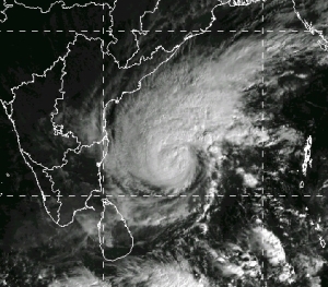
INSAT-3D Image 8 Dec 2013 0230 UTC (Source: IMD web site)
After Phailin, Helen, and Lehar, it is now Madi, the fourth successive cyclone to form in the Bay of Bengal in eight weeks. Cyclone Phailin had a straight line path and the landfall point could be predicted well in advance. There was enough time for a massive evacuation drive to be executed and for TV camera teams to place themselves at Gopalpur to give a live account of the arrival of the storm.
Helen was a much weaker storm and it had a shorter track as well. Lehar was another severe cyclonic storm. But it was different from Phailin. It looked as if Lehar was hesitant to strike the coast. Eventually it adopted a self-destructive path, went into cooler seas, and ended in a whimper far away from land. Lehar was like a left-over Diwali phataka (loud cracker) that failed to burst.
As I write this post on 8 December 2013, Madi is a cyclonic storm over the Bay of Bengal, and it is currently threatening no one in particular. As a BBC World News weathercaster put it, Madi is aimlessly wandering. Weather prediction models are not able to predict for sure where Madi is heading or what is going to happen to it. It is even said to be in quasi-stationary motion for whatever that means.
I have always felt that every cyclone has a mind of its own. So for meteorologists, cyclone prediction still largely remains a guessing game. As for the modelers, every new cyclone only brings an old message that they yet have a long way to go…

Dec 10, 2013 @ 06:29:53
thanks sir ! hope to see many more interesting articles about climate and weather written by you .
regards
Abhishek !
Dec 09, 2013 @ 02:37:37
Sir , i just found your blog and i really liked it . like many others browsing through this blog , i am interested in meteorology ( and observational astronomy if i can add ) . so as i like to observe night sky with my larger than usual binocular , i want weather to be clear and crisp . however if a potential cyclone brews in sea , i take note of it and stack satellite weather maps and try to understand how the system moves in different times of the year .
so i would like to ask you few question !
1. generally the cyclones or typhoons move west ward ( mostly north west direction in northern hemisphere . but why some cyclones like madi are predicted to move north east direction ?
2. as it is winter already the land and sea are relatively cooler .so this type of cyclones or system should not form this time of the year as weather condition is not suitable for them . or is it due to active north east monsoon ? so why so much frequent cyclones like helen , lehar and madi are forming now ?
yours faithfully
Abhishek
Dec 09, 2013 @ 04:24:44
Dear Abhishek,
You have asked a lot of questions. But I will try to answer all of them briefly.
The cyclones are steered by the large scale flow in the upper levels of the atmosphere. They cannot cross through high pressure ridges and have to go around them. Depending on the alignment of the ridge, the cyclone may go N, NE or NW.
During the post-sw-monsoon months, the sea can be quite warm and cyclones can form. Similarly in the pre-sw-monsoon months too. Even in winter, the oceans do not cool as much as the land. So cyclones cannot be ruled out.
The number of cyclones that form in the Indian seas varies from year to year. But the number is small. It is difficult therefore to speculate on the reasons behind the variability.
Best wishes,
R R Kelkar
Dec 09, 2013 @ 13:48:18
thanks sir for the reply .
few more queries ,
1.is it right that cyclones do not form around equator and to the north of equator ,
cyclone’s wind is always in counter clockwise direction ?
2. as u said , in winter ocean temperature remains warmer than land , probably that’s why cyclones in winter lose much of its strength as it reaches near land . that’s what happened with lehar and probably will happen with madi too .
3. sir , i often hears about ‘ models ‘ for predicting the path of a cyclone ? what are those models ?
eagerly awaiting for your reply ,
good evening ,
Abhishek ..
Dec 09, 2013 @ 13:53:44
About 1 and 2, you are quite right. About the model, do a google search.
Dec 08, 2013 @ 12:09:40
Respected Sir,
As You have mentioned cyclone prediction as a guessing game; I would say that both cricket and cyclone are unpredictable games. .Thank God that most models now predict that Madi will weaken and track south-westward. .I hope that weakened Madi will reach TN coast’s soon:)
Dec 08, 2013 @ 11:05:59
Respected Sir,
Thank You for Your wonderful blog on climate. its soo nice. . .I’ll pray to God that He should give You long life so that You can guide the youngsters and Your service to the Nation continues…
Dec 08, 2013 @ 07:02:59
thanks for replying sir. .I’m also like Madi cyclone wandering aimlessly in life. from boyhood I wanted to become a meteorologist but I failed to work on it and now, it has been eight years since I’ve completed my +2 studies and yet I’m only a mere person aimlessly wandering the weather websites..
Dec 08, 2013 @ 07:08:12
You can still accomplish your aim … work for it.
Dec 08, 2013 @ 08:16:38
Sir thanks for boosting confidence in me. .still it’s not impossible for me to become a meteorologist but I have a very little hope as its has been eight years since I’ve left studying..if I get blessed by a noble soul like you then l’ll surely become:) please bless me .
Dec 08, 2013 @ 09:05:46
Dear Vinoth,
I do not know you but surely I can bless you! There is a simple formula for a successful life:
(1) Have faith in God
(2) Pray regularly
(3) Use the abilities that God has given you.
(4) Put your heart into your work.
There you go..!
R R Kelkar
Dec 08, 2013 @ 10:38:57
Sir thank you very much. .until I previously replied you, I also was not knowing who are you? Actually I opened this link when I got results for cyclone madi in Google..but now after browsing about you I found out that you are the Former Director General of IMD. Like Sachin is the God of Cricket YOU are the God of Indian Meteorology. .From here onwards I’ll call You Respected Sir:) actually I discontinued my studies upto twelfth as further I didn’t know what should I do to become a meteorologist. ie.where meteorology course is offered here in Chennai and neither I seriously searched for it..but after reading your blog I think no one will suffer like me and there is a good scope for meteorology in india:)
Dec 08, 2013 @ 04:57:46
I myself and the people of tamilnadu will be very happy if the Madi cyclone gradually weakens and enters our rain deficient state. I don’t know why neither none of the cyclones haven’t come here?? please tell me if there is any technique to attract the cyclones;)…finally I have one question for you about the nilam cyclone which crossed in Chennai near mahabhalipuram last year. .why didn’t it rain while or after landfall???
Dec 08, 2013 @ 06:02:04
Dear Vinoth,
Thanks for your comment.
One, the path of a cyclone is the resultant of several conflicting factors. Some cyclones are moved by external factors, some cyclones influence the environment and make way for themselves.
Two, the rainfall is decided by the moisture influx into the cyclone.
Three, there is no way of changing the paths of cyclones artificially.
Best wishes,
R R Kelkar